Property Record
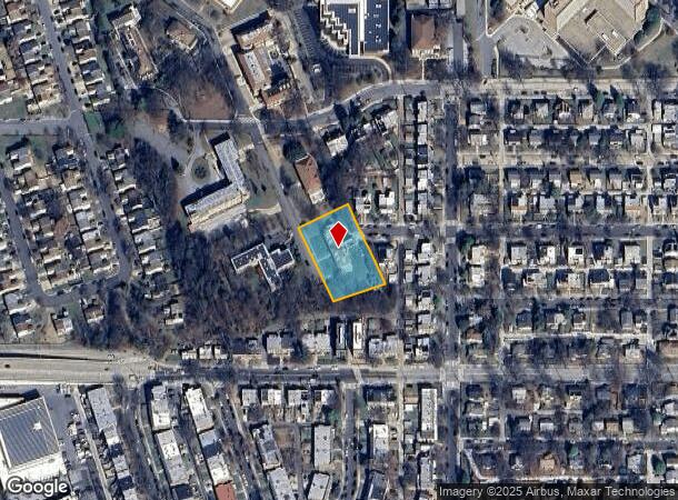
831 Varnum St Ne, Washington, DC 20017
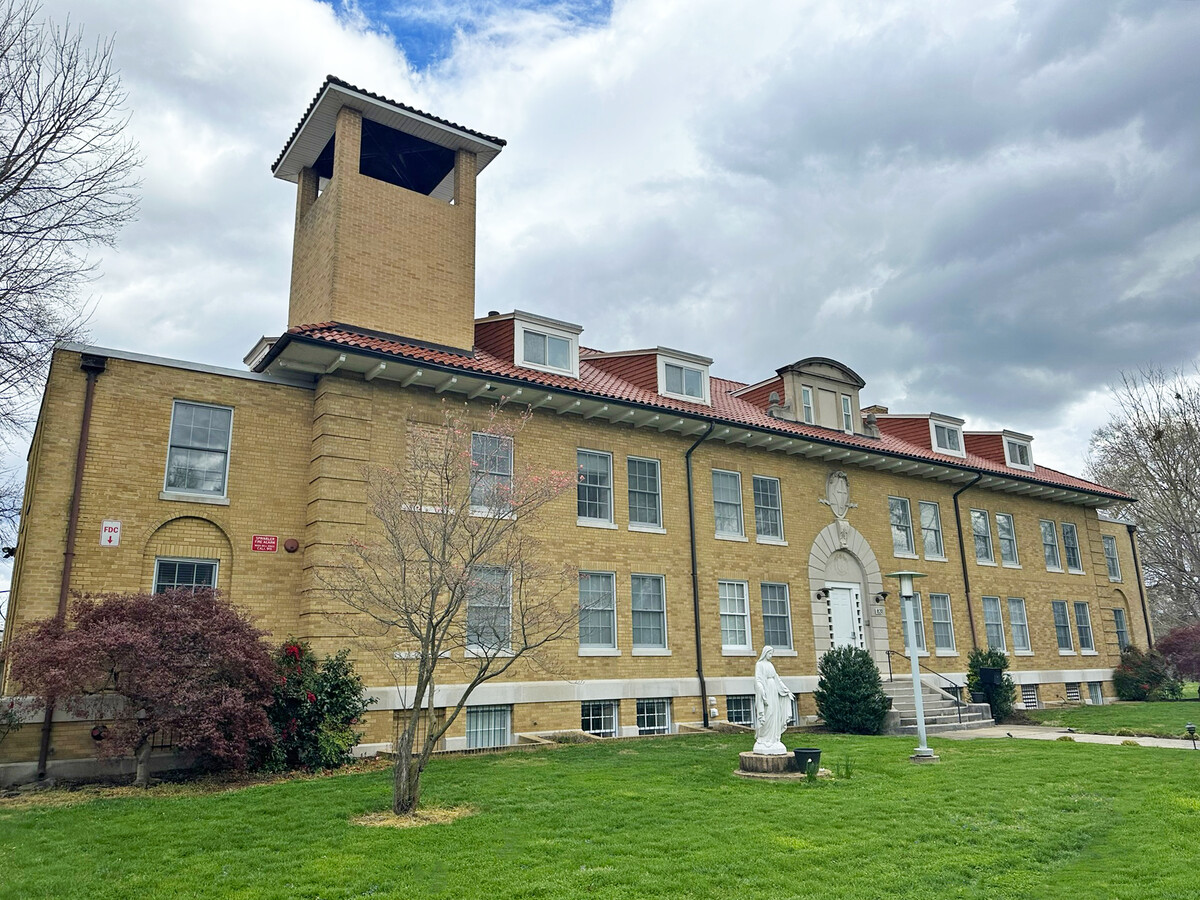

This Property Is For Sale
NEARBY LISTINGS FOR SALE OR LEASE
Property Detail
831 Varnum St Ne
Washington-Arlington-Alexandria, DC-VA-MD-WV
Brookland
3810-0135
SQUARE 3810 LOT 0135 NBHD: BROOKLAND
Religious
District of Columbia
X
District of Columbia
24033C0128E
135
0
0.80 AC
2024
Michigan Park
009504
Washington, DC
23,154 SF
DEMOGRAPHICS near 831 Varnum St Ne
1 Mile
3 Mile
5 Mile
2024 Total Population
21,693
337,132
785,968
2029 Population
19,443
312,372
735,214
Pop Growth 2024-2029
(10.37%)
(7.34%)
(6.46%)
Average Age
40
37
37
2024 Total Households
8,780
144,096
339,317
HH Growth 2024-2029
(11.33%)
(8.05%)
(7.46%)
Median Household Inc
$90,911
$89,795
$94,573
Avg Household Size
2.30
2.20
2.20
2024 Avg HH Vehicles
1.00
1.00
1.00
Median Home Value
$633,139
$656,470
$653,584
Median Year Built
1953
1954
1959
Nearby Places
- Restaurants
- Banks
- Shops
- Fitness
- Groceries
PUBLIC TRANSPORTATION
TRANSIT/SUBWAY
Brookland-Cua (Red Line - Washington Metropolitan Area Transit Authority Metrorail (Metrorail))
DRIVE
WALK
Distance
Brookland-Cua (Red Line - Washington Metropolitan Area Transit Authority Metrorail (Metrorail))
2 min
13 min
0.7 mi
COMMUTER RAIL
Riverdale (Camden Line - Maryland Area Regional Commuter Trains (The MARC))
DRIVE
WALK
Distance
Riverdale (Camden Line - Maryland Area Regional Commuter Trains (The MARC))
8 min
3.9 mi
Union Station (Brunswick Line - Maryland Area Regional Commuter Trains (The MARC), Camden Line - Maryland Area Regional Commuter Trains (The MARC), Fredericksburg Line - Maryland Area Regional Commuter Trains (The MARC), Manassas Line - Maryland Area Regional Commuter Trains (The MARC), Penn Line - Maryland Area Regional Commuter Trains (The MARC), Red Line - Maryland Area Regional Commuter Trains (The MARC))
DRIVE
WALK
Distance
Union Station (Brunswick Line - Maryland Area Regional Commuter Trains (The MARC), Camden Line - Maryland Area Regional Commuter Trains (The MARC), Fredericksburg Line - Maryland Area Regional Commuter Trains (The MARC), Manassas Line - Maryland Area Regional Commuter Trains (The MARC), Penn Line - Maryland Area Regional Commuter Trains (The MARC), Red Line - Maryland Area Regional Commuter Trains (The MARC))
9 min
4.0 mi
AIRPORT
Ronald Reagan Washington Ntl
DRIVE
WALK
Distance
Ronald Reagan Washington Ntl
17 min
9.3 mi
Baltimore/Washington International Thurgood Marshall
DRIVE
WALK
Distance
Baltimore/Washington International Thurgood Marshall
45 min
28.1 mi
Washington Dulles International
DRIVE
WALK
Distance
Washington Dulles International
52 min
32.0 mi
Freight Ports
Port of Baltimore
DRIVE
WALK
Distance
Port of Baltimore
51 min
35.5 mi
Nearby Properties
Address
Land Use
TOTAL SIZE
Lot Size
Zoning
Address
Land Use
TOTAL SIZE
Lot Size
Zoning
418.97 AC
MU-4,UNZON
Address
Land Use
TOTAL SIZE
Lot Size
Zoning
120 SF
276.66 AC
UNZONED
Address
Land Use
TOTAL SIZE
Lot Size
Zoning
1,642,951 SF
95.12 AC
RF-1
Address
Land Use
TOTAL SIZE
Lot Size
Zoning
1,083,392 SF
15.33 AC
PDR-3,RA-2
Address
Land Use
TOTAL SIZE
Lot Size
Zoning
95.32 AC
RA-1
Address
Land Use
TOTAL SIZE
Lot Size
Zoning
314,995 SF
5.82 AC
D-5
Address
Land Use
TOTAL SIZE
Lot Size
Zoning
589,000 SF
1.39 AC
D-5
Address
Land Use
TOTAL SIZE
Lot Size
Zoning
1,835,827 SF
34.66 AC
UNZONED
Address
Land Use
TOTAL SIZE
Lot Size
Zoning
6.54 AC
MU-4,RF-1
Address
Land Use
TOTAL SIZE
Lot Size
Zoning
823,802 SF
7.30 AC
MU-2
Address
Land Use
TOTAL SIZE
Lot Size
Zoning
231,304 SF
37.44 AC
RA-1
Address
Land Use
TOTAL SIZE
Lot Size
Zoning
1,095,275 SF
30.70 AC
MU-4,RA-2
Address
Land Use
TOTAL SIZE
Lot Size
Zoning
545,000 SF
0.81 AC
D-5
Address
Land Use
TOTAL SIZE
Lot Size
Zoning
2,985,682 SF
4.33 AC
RSF65
Address
Land Use
TOTAL SIZE
Lot Size
Zoning
256,187 SF
8.97 AC
RA-2
Address
Land Use
TOTAL SIZE
Lot Size
Zoning
25,724 SF
9.46 AC
RA-2,RF-1
Address
Land Use
TOTAL SIZE
Lot Size
Zoning
416,764 SF
1.56 AC
D-5
Address
Land Use
TOTAL SIZE
Lot Size
Zoning
23,072 SF
1.13 AC
MU-6B
Address
Land Use
TOTAL SIZE
Lot Size
Zoning
503,872 SF
1.24 AC
D-5
Address
Land Use
TOTAL SIZE
Lot Size
Zoning
755,499 SF
1.75 AC
PDR-3,USN
Address
Land Use
TOTAL SIZE
Lot Size
Zoning
538,974 SF
1.26 AC
PDR-3
Address
Land Use
TOTAL SIZE
Lot Size
Zoning
520,000 SF
2.65 AC
MU-10,RA-5
Address
Land Use
TOTAL SIZE
Lot Size
Zoning
360,000 SF
0.86 AC
D-5
Address
Land Use
TOTAL SIZE
Lot Size
Zoning
346,026 SF
0.79 AC
D-5
Address
Land Use
TOTAL SIZE
Lot Size
Zoning
450,000 SF
1.04 AC
D-5
Address
Land Use
TOTAL SIZE
Lot Size
Zoning
356,114 SF
2.97 AC
D-5
Address
Land Use
TOTAL SIZE
Lot Size
Zoning
449,882 SF
2.32 AC
NC-10,RF-1
Address
Land Use
TOTAL SIZE
Lot Size
Zoning
394,400 SF
1.28 AC
D-5
Address
Land Use
TOTAL SIZE
Lot Size
Zoning
299,722 SF
0.79 AC
D-5
Address
Land Use
TOTAL SIZE
Lot Size
Zoning
549,750 SF
0.87 AC
D-4-R
The World's #1 Commercial Real Estate Marketplace
Connect with us
© 2025 CoStar Group
The information above has been obtained from sources believed reliable. While we do not doubt its accuracy we have not verified it and make no guarantee, warranty or representation about it. It is your responsibility to independently confirm its accuracy and completeness. Any projections, opinions, assumptions, or estimates used are for example only and do not represent the current or future performance of the property. The value of this transaction to you depends on tax and other factors which should be evaluated by your tax, financial, and legal advisors. You and your advisors should conduct a careful, independent investigation of the property to determine to your satisfaction the suitability of the property for your needs.